As the 7th largest country in the world, India stands apart from the rest of Asia, marked off as it is by mountains and the sea, which give the country a distinct geographical entity. Geography of India An Introduction For UPSC IAS
Bounded by the Great Himalayas in the north, it stretches southwards and at the Tropic of Cancer, tapers off into the Indian Ocean between the Bay of Bengal on the east and the Arabian Sea on the west.
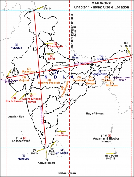
Map-key:
- The island groups of India lying in the Arabian Sea and the Bay of Bengal.
- The countries constituting Indian Subcontinent.
- The states through which the Tropic of Cancer passes.
- The northernmost latitude in degrees (Indira Col in Jammu and Kashmir).
- The southernmost latitude of the Indian mainland in degrees (Kanyakumari in Tamil Nadu). Note that the southernmost point of India is the Indira Point which is the southernmost point of Great Nicobar Island of the Andaman and Nicobar archipelago. The Indira Point was previously known as the Pygmalion Point or the Parson Point.
- The eastern and the westernmost longitudes in degrees.
- The place situated on the three seas.
- The strait separating Sri Lanka and India.
- The Union Territories of India.
Let’s take a look at India’s geographical setting:
Various Geographical facts at a glance
Location– India lies to the north of the equator in Southern Asia
Geographical Extent– The Indian mainland:
Latitude: 8°4’N to 37°6′ North Longitude: 68°7′ E to 97°25′ East
-India’s territorial sea is 12 nautical miles (about 21.9 km) from the main coastline.
-India has absolute rights to use this area.* (See the note below this table)
-Our southern boundary extends up to 6°45’N latitude in the Bay of Bengal (the
-Indira Point in Andaman and Nicobar Islands in the Bay of Bengal and Lakshadweep Islands in the Arabian Sea.
Gujarat has the longest coastline in comparison to other coastal states followed by
Andhra Pradesh.
Coastline Area
India measures 3,214 km from north to south and 2,933 km from east to west with a
total area of 3,287,263 sq km. Areawise is the largest state and Goa the smallest. Geography of India An Introduction For UPSC IAS
Bordering Countries:
Afghanistan and Pakistan in the northwest. (Durand Line – the borderline between India and Afghanistan, presently separates PoK and Afghanistan; Radcliffe Line – the borderline between India and Pakistan, and India and Bangladesh)
China, Bhutan, and Nepal in the north. (McMohan line – the borderline between India and China) Geography of India An Introduction For UPSC IAS
Myanmar in the east; and Bangladesh in the east of West Bengal. Sri Lanka is separated from India by a narrow channel of sea, formed by Palk Strait and the Gulf of Mannar.
*Note: [Contiguous Zone – The area ahead of the territorial sea frontier and 24 nautical miles from the main coastline is known as the contiguous zone. In this area, India has fiscal rights, excise duty rights, rights related to pollution control, and right to implement immigration laws.
The nautical region ahead of the contiguous zone which is up to 200 nautical miles from the main coastline is known as the Exclusive Economic Zone (EEZ). In this region India has rights to survey, exploitation, conservation, and research on mineral resources, marine life, etc.]


Observe India’s latitudinal and longitudinal extent. Do you notice that while both the latitudinal and longitudinal extent is roughly about 30 degrees, the actual distance measured from north to south extremity is 3,214 km and that from east to west is only 2,933 km!
What is the reason for this difference?
This is because:
Degrees of latitude are parallel so the distance between each degree remains almost constant but since degrees of longitude are farthest apart at the equator and converge at the poles, their distance varies greatly. See the following figure to understand better:

Geography of India An Introduction For UPSC IAS
The longitudinal extent and its implications:
The longitudinal extent of India is 30 degrees. As the sun rises in the east and sets in the west; it takes 4 minutes for the sun to move across 1 longitude.
Thus, the easternmost point of India would be 2 hours ahead of the westernmost point (30 x 4 = 120 minutes), in accordance with the local time.
This difference in time might create confusion in air and rail timings and so many other things across the two states. To avoid this confusion, 82°30′ East longitude is taken as the Standard Time Meridian of India, and its local time is taken as a standard throughout the country. Geography of India An Introduction For UPSC IAS
The latitudinal extent and its implications:
- The difference between the length of day and night in southern most part of India is much less only about 45 minutes as they are situated near the equator. This difference between day and night in the northern parts of India steadily goes on increasing till it becomes as much as 5 hours.
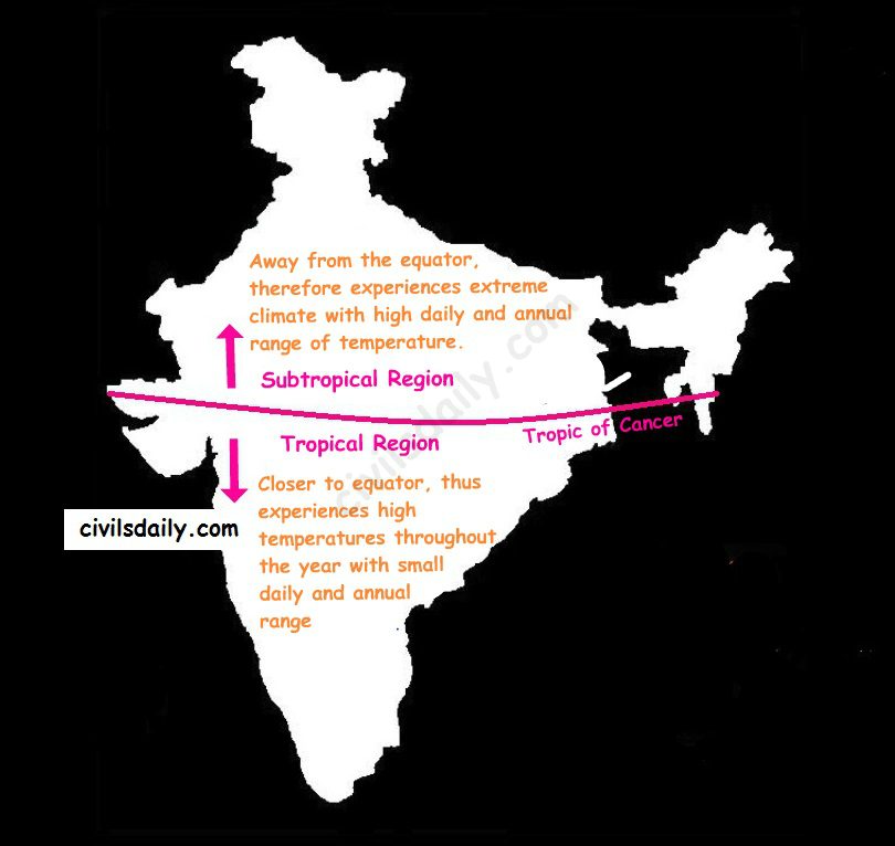
- The Tropic of Cancer passes almost halfway through the country. Thus half of the country to the south of the Tropic of Cancer is situated in the Tropical or Torrid zone and the other half lying north of the Tropic of Cancer falls in the Subtropical zone. This location is responsible for large variations in landforms, climate, soil types and natural vegetation in the country. Wondering how?
Let’s try and understand:
Also,
- Areas closer to the coast would experience greater rainfall
- And, as we move towards the interior areas, the moisture content of clouds and hence the rainfall experienced would decrease. Geography of India An Introduction For UPSC IAS
These rules broadly define the distribution of rainfall in the country as can be seen in the map below:

Still wondering how this influences the soil types and vegetation?
Rainfall experienced by a region, in turn, plays an important role in determining the soil type in that region. For example:
- Areas of high rainfall (>200cm) –> Nutrients seep to lower layers –> laterization of soil. Laterite soils are thus found in these areas.
Further, in these areas: Hot and humid climate + Abundant rainfall = favorable conditions for vegetation growth. As a result, the vegetation here is very dense and multilayered with evergreens [Also, called Tropical Evergreen Forests as we will discuss later]
- Similarly, in areas with 100-200cm of rainfall –> Red and Yellow soils
The upper layer of Red soils appears red due to the presence of iron. When the rainfall is in the range of 100-200cm, the rainwater tends to seep into the second layer of soil. Red soils appear yellow in hydrated form, thus the second layer of soils in these areas is yellow in color.
- In areas of low rainfall – less than 60cm, we find Desert Soil (or arid soil): This soil is derived from the disintegration of adjacent rocks and is largely blown from coastal regions and Indus Valley. The low rainfall dictates the type of vegetation, prominent features of which are small leaves, thick bark and long roots. [Also, called Tropical Thorny Vegetation as we will discuss later] Geography of India An Introduction For UPSC IAS
Important Points to Remember
Geographical Extent and Frontiers
Latitudinal and Longitudinal Extent: India lies between latitudes 8°4’N and 37°6’N and longitudes 68°7’E and 97°25’E, encompassing a huge area that contributes to its varied climatic conditions.
Neighboring Nations: India is bordered by Pakistan and Afghanistan to the northwest, China, Nepal, and Bhutan in the north, and Myanmar and Bangladesh in the east. By sea, it is close to Sri Lanka and the Maldives.
- Major Physiographic Divisions
The Himalayan Mountains: These are young fold mountains in the north, which serve as a natural defense and affect the climate by preventing cold winds from Central Asia. They are classified as:
Trans-Himalayas: Located to the north of the Great Himalayas and encompasses areas such as Ladakh.
Greater Himalayas (Himadri): This is the highest range with major peaks such as Mount Everest and Kanchenjunga.
Lesser Himalayas (Himachal): Famous for hill stations such as Shimla and Darjeeling.
Shiwaliks: The outermost range of foothills.
The Northern Plains: Created by the alluvial deposits of rivers such as the Indus, Ganga, and Brahmaputra, these plains are fertile for agriculture and densely populated.
The Peninsular Plateau: An ancient landmass made up of the Deccan Plateau, bordered by the Western and Eastern Ghats. It is mineral-rich and has characteristic geological features.
The Coastal Plains: Covering the Arabian Sea and Bay of Bengal, these plains comprise the Konkan, Malabar, Coromandel, and Northern Circar coasts.
The Islands: The Bay of Bengal’s Andaman and Nicobar Islands and the Arabian Sea’s Lakshadweep Islands contribute to India’s importance by the sea.
- Drainage System
Himalayan Rivers: Perennial rivers such as the Ganga, Yamuna, and Brahmaputra flow from glaciers, catering to large-scale agriculture and high population densities.
Peninsular Rivers: The rivers like Godavari, Krishna, and Kaveri are rain-fed and exhibit seasonal flow patterns.
- Climate
Monsoons: Southwest Monsoon (June to September) contributes the most to rainfall, while Northeast Monsoon (October to December) influences the southeastern areas.
Climatic Regions: The regions in India range from the deserts of Rajasthan to the moistest locations on the globe like Mawsynram in Meghalaya.
- Soils
Alluvial Soil: Dominant in the northern plains, best suited for crops such as wheat and rice.
Black Soil: Present in the Deccan Plateau, best suited for cotton growth.
Red and Laterite Soils: Prevalent in southern and eastern parts, best suited for crops such as millets and pulses.
- Natural Vegetation and Wildlife
Flora: Varying from tropical rainforests in the Andaman Islands to alpine flora in the Himalayas.
Fauna: Habitat of varied species, including Bengal tigers, Asian elephants, and one-horned rhinoceroses.
- Mineral Resources
Coal and Iron Ore: Rich deposits in states such as Jharkhand, Odisha, and Chhattisgarh powering industries.
Bauxite and Mica: Large deposits supporting the aluminum and electronics sectors.
- Geopolitical Importance
Strategic Position: Geographically situated between the Middle East and Southeast Asia, India is central to regional politics and trade.
Maritime Frontiers: With an extensive coastline, India has controlling influence over vital sea lanes in the Indian Ocean.