Geography as a new branch of study developed more than 2000 years ago. Eratosthenes (2 cent BC) is considered to be the father of Geography.
Do you know these facts in Geography,
The earth’s Geographic North Pole and the Magnetic North Pole are not located at the same point. Also, while the magnetic north pole is a scientific reality, the geographic North Pole is a imaginary point created for practical convenience.
A Portuguese explorer Magellan’s (1480–1521) expedition was the first to circumnavigate the earth, there by practically proving that the earth is a sphere
Water in a bath tub or sink drains in a clockwise direction in Northern Hemisphere and anticlockwise direction in Southern Hemisphere. However exactly on Equator water drains without any spin in a straight line.
The Crust of the earth (which includes oceanic and continental crust) makes up less than 1% of the total mass of the earth. The Mantle and Core account for the rest of 99% of mass.
The tallest mountain in the world is not Himalayas, but Mauna Kea, whose base is 6000 metres below sea level and 4000 metres above sea level.
The surface of the earth is constantly in motion due to plate tectonics, we cannot perceive it because the rate of movement is very slow.
The lowest point on land is Dead Sea, which is 420 Mts below Mean Sea Level. The deepest point in the ocean is Mariana’s Trench about 11,000 Mts deep.
The earth’s magnetic north and magnetic south interchange their position over a period of time. This is called as Magnetic Reversal. They occur randomly and we still are not very clear about the causes and impacts of it.
Although the age of earth is 4.5 billion years, the oldest mountain range on earth is 3.5 billion years only.
The inclination of the earth causes different seasons on the planet. If the earth is not inclined, there will be no alternating summer and winter in any part of the earth.
1.There are no bridges over the Amazon river in Brazil.
This is primarily due to the immense width of the river (1-10 km, up to 50 km in floods), soft, unstable soil that shifts constantly, and the lack of connecting highway infrastructure in the region.
2. France has 12 time zones, The most time zones of any country in the world.
While Metropolitan France in Europe uses only one time zone (Central European Time), the vast majority of the 12 zones are due to territories in the Caribbean, South America, the Indian Ocean, and the Pacific.
If you include France’s Antarctica claim, Terre Adélie, then it has 13 Time zones. Russia has 11 Time Zones while China has 1.
3. Second Street is the most common street name in the United States. This is because many streets named First Street have been renamed Main Street (or their 1st Street was never called First Street and it was called Main instead).
4. Liechtenstein & Uzbekistan are the only doubly-landlocked countries in the world. Meaning they are land locked countries, surrounded exclusively by other land locked countries).
5. There is only 1 country between Finland and North Korea.
6. The majority of US states (27 last time I counted) have land north of Canada's southernmost point.
Province of Ontario, Canada
These include California, Alaska, Washington, Oregon, Idaho, Montana, Nevada, Utah, Wyoming, North Dakota, South Dakota, Nebraska, Minnesota, lowa, Wisconsin, Illinois, Michigan, Pennsylvania, New York, Maine, Vermont, New Hampshire, Massachusetts, Connecticut, Rhode Island, Ohio and Indiana.
7. The state of Wyoming only has 2 sets of escalators.
8. The United States is the westernmost country in the world and the easternmost country in the world (because of Alaska).
9. Antarctica has a hidden underwater mountain range that is about the same height as the Ural Mountains called the Gamburtsev Mountain Range.
10. The Saharan Desert is the hottest desert in the world, but not the largest. The largest is the Antarctic Desert.
The continent is considered a desert because of the extremely low precipitation in Antarctica. Antarctica is not only a desert, it is the driest continent in the world.
11. Greenland is further north than Iceland. Greenland is further south than Iceland. Greenland is further west than Iceland. Greenland is further east than Iceland.
12. Africa is closer to Canada than it is to the U.S.
The closest U.S. state to Africa is Maine.
13. The continent of Asia has more surface area than the moon.
The moon is pretty freakin' big, with a surface area of 14.6 million square miles. But Asia, the largest continent in the world, practically dwarfs it in size. Asia takes up 17.2 million square miles.
14. About 90% of the world's population lives in the northern hemisphere.
India does not have only one desert but two. The first one is the Thar Desert and the second one is Laddakh, a high altitude cold desert.
India has the world's largest river island Majuli in Brahmaputra river,Assam.
India has the world's smallest river island too. It is Umananda island in the Brahmaputra,Assam.
Kuttanad, in the state of Kerala, which is located at −2.2 m below the sea level,is the lowest point of the nation while Kanchenjunga, situated at an altitude of 8, 598 m above the sea level is the highest point of India.
Dras in western Ladakh is the coldest place in India.
Lakshadweep is the smallest union territory while Andaman and Nicobar Islands is the biggest one.
The union territory of Pondicherry has four exclaves called Pondicherry, Karaikal, Mahe and Yanam in three different states of Tamil Nadu, Kerala and Andhra Pradesh respectively.
Mahe in Pondicherry is the smallest district of our country while Kachchh in Gujarat is the biggest one.
The eastern-most point of our country is Kibithu in Arunachal Pradesh.
The western-most point of our nation is Ghuar Mota in Gujarat.
Southern Most Point of India is Indira Point, Nicobar Islands.
Northern Most Point of India is Indira Col in Siachen Glacier
Southern Most Point on Indian Mainland is Cape Comorin, Kanyakumari.
The Aravallis are the India's oldest mountain range.
The highest peaks in the Eastern and the Western Ghats are Arma Konda (1680m) in Andhra Pradesh and Anaimudi (2695m) in Kerala respectively.
Chilika lake is India's largest and world's second largest brackish water/estuarine lake while Wular lake is the largest fresh water lake formed as a result of tectonic activity and fed by river Jhelum.
The Keibul Lamjao National Park in the Indian state of Manipur is the only floating park in the world.
India's only active volcano is located on Barren island of Andaman and Nicobar islands.
Lonar Crater Lake in Maharashtra is the only salt water lake in the basaltic rock in the world.
As the 7th largest country in the world, India stands apart from the rest of Asia, marked off as it is by mountains and the sea, which give the country a distinct geographical entity. Geography of India An Introduction For UPSC IAS
Bounded by the Great Himalayas in the north, it stretches southwards and at the Tropic of Cancer, tapers off into the Indian Ocean between the Bay of Bengal on the east and the Arabian Sea on the west.
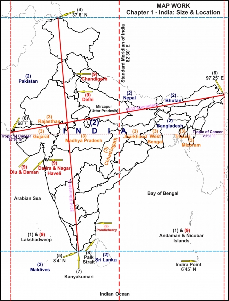
Map-key:
The island groups of India lying in the Arabian Sea and the Bay of Bengal.
The countries constituting Indian Subcontinent.
The states through which the Tropic of Cancer passes.
The northernmost latitude in degrees (Indira Col in Jammu and Kashmir).
The southernmost latitude of the Indian mainland in degrees (Kanyakumari in Tamil Nadu). Note that the southernmost point of India is the Indira Point which is the southernmost point of Great Nicobar Island of the Andaman and Nicobar archipelago. The Indira Point was previously known as the Pygmalion Point or the Parson Point.
The eastern and the westernmost longitudes in degrees.
The place situated on the three seas.
The strait separating Sri Lanka and India.
The Union Territories of India.
Let’s take a look at India’s geographical setting:
Various Geographical facts at a glance Location– India lies to the north of the equator in Southern Asia Geographical Extent– The Indian mainland: Latitude: 8°4’N to 37°6′ North Longitude: 68°7′ E to 97°25′ East
-India’s territorial sea is 12 nautical miles (about 21.9 km) from the main coastline. -India has absolute rights to use this area.* (See the note below this table) -Our southern boundary extends up to 6°45’N latitude in the Bay of Bengal (the -Indira Point in Andaman and Nicobar Islands in the Bay of Bengal and Lakshadweep Islands in the Arabian Sea. Gujarat has the longest coastline in comparison to other coastal states followed by Andhra Pradesh.
CoastlineArea India measures 3,214 km from north to south and 2,933 km from east to west with a total area of 3,287,263 sq km. Areawise is the largest state and Goa the smallest. Geography of India An Introduction For UPSC IAS
Bordering Countries: Afghanistan and Pakistan in the northwest. (Durand Line – the borderline between India and Afghanistan, presently separates PoK and Afghanistan; Radcliffe Line – the borderline between India and Pakistan, and India and Bangladesh)
China, Bhutan, and Nepal in the north. (McMohan line – the borderline between India and China) Geography of India An Introduction For UPSC IAS
Myanmar in the east; and Bangladesh in the east of West Bengal. Sri Lanka is separated from India by a narrow channel of sea, formed by Palk Strait and the Gulf of Mannar.
*Note: [Contiguous Zone – The area ahead of the territorial sea frontier and 24 nautical miles from the main coastline is known as the contiguous zone. In this area, India has fiscal rights, excise duty rights, rights related to pollution control, and right to implement immigration laws.
The nautical region ahead of the contiguous zone which is up to 200 nautical miles from the main coastline is known as the Exclusive Economic Zone (EEZ). In this region India has rights to survey, exploitation, conservation, and research on mineral resources, marine life, etc.]
Territorial Sea, Contiguous Zone, and Exclusive Economic Zone of India
Observe India’s latitudinal and longitudinal extent. Do you notice that while both the latitudinal and longitudinal extent is roughly about 30 degrees, the actual distance measured from north to south extremity is 3,214 km and that from east to west is only 2,933 km!
What is the reason for this difference?
This is because:
Degrees of latitude are parallel so the distance between each degree remains almost constant but since degrees of longitude are farthest apart at the equator and converge at the poles, their distance varies greatly. See the following figure to understand better:
Geography of India An Introduction For UPSC IAS
The longitudinal extent and its implications:
The longitudinal extent of India is 30 degrees. As the sun rises in the east and sets in the west; it takes 4 minutes for the sun to move across 1 longitude.
Thus, the easternmost point of India would be 2 hours ahead of the westernmost point (30 x 4 = 120 minutes), in accordance with the local time.
This difference in time might create confusion in air and rail timings and so many other things across the two states. To avoid this confusion, 82°30′ East longitude is taken as the Standard Time Meridian of India, and its local time is taken as a standard throughout the country. Geography of India An Introduction For UPSC IAS
The latitudinal extent and its implications:
The difference between the length of day and night in southern most part of India is much less only about 45 minutes as they are situated near the equator. This difference between day and night in the northern parts of India steadily goes on increasing till it becomes as much as 5 hours.
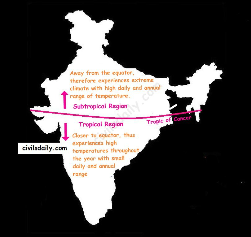
The Tropic of Cancer passes almost halfway through the country. Thus half of the country to the south of the Tropic of Cancer is situated in the Tropical or Torrid zone and the other half lying north of the Tropic of Cancer falls in the Subtropical zone. This location is responsible for large variations in landforms, climate, soil types and natural vegetation in the country. Wondering how?
Let’s try and understand:
Also,
Areas closer to the coast would experience greater rainfall
And, as we move towards the interior areas, the moisture content of clouds and hence the rainfall experienced would decrease. Geography of India An Introduction For UPSC IAS
These rules broadly define the distribution of rainfall in the country as can be seen in the map below:
Still wondering how this influences the soil types and vegetation?
Rainfall experienced by a region, in turn, plays an important role in determining the soil type in that region. For example:
Areas of high rainfall (>200cm) –> Nutrients seep to lower layers –> laterization of soil. Laterite soils are thus found in these areas.
Further, in these areas: Hot and humid climate + Abundant rainfall = favorable conditions for vegetation growth. As a result, the vegetation here is very dense and multilayered with evergreens [Also, called Tropical Evergreen Forests as we will discuss later]
Similarly, in areas with 100-200cm of rainfall –> Red and Yellow soils
The upper layer of Red soils appears red due to the presence of iron. When the rainfall is in the range of 100-200cm, the rainwater tends to seep into the second layer of soil. Red soils appear yellow in hydrated form, thus the second layer of soils in these areas is yellow in color.
In areas of low rainfall – less than 60cm, we find Desert Soil (or arid soil): This soil is derived from the disintegration of adjacent rocks and is largely blown from coastal regions and Indus Valley. The low rainfall dictates the type of vegetation, prominent features of which are small leaves, thick bark and long roots. [Also, called Tropical Thorny Vegetation as we will discuss later] Geography of India An Introduction For UPSC IAS
Important Points to Remember
Geographical Extent and Frontiers
Latitudinal and Longitudinal Extent: India lies between latitudes 8°4’N and 37°6’N and longitudes 68°7’E and 97°25’E, encompassing a huge area that contributes to its varied climatic conditions.
Neighboring Nations: India is bordered by Pakistan and Afghanistan to the northwest, China, Nepal, and Bhutan in the north, and Myanmar and Bangladesh in the east. By sea, it is close to Sri Lanka and the Maldives.
Major Physiographic Divisions
The Himalayan Mountains: These are young fold mountains in the north, which serve as a natural defense and affect the climate by preventing cold winds from Central Asia. They are classified as:
Trans-Himalayas: Located to the north of the Great Himalayas and encompasses areas such as Ladakh.
Greater Himalayas (Himadri): This is the highest range with major peaks such as Mount Everest and Kanchenjunga.
Lesser Himalayas (Himachal): Famous for hill stations such as Shimla and Darjeeling.
Shiwaliks: The outermost range of foothills.
The Northern Plains: Created by the alluvial deposits of rivers such as the Indus, Ganga, and Brahmaputra, these plains are fertile for agriculture and densely populated.
The Peninsular Plateau: An ancient landmass made up of the Deccan Plateau, bordered by the Western and Eastern Ghats. It is mineral-rich and has characteristic geological features.
The Coastal Plains: Covering the Arabian Sea and Bay of Bengal, these plains comprise the Konkan, Malabar, Coromandel, and Northern Circar coasts.
The Islands: The Bay of Bengal’s Andaman and Nicobar Islands and the Arabian Sea’s Lakshadweep Islands contribute to India’s importance by the sea.
Drainage System
Himalayan Rivers: Perennial rivers such as the Ganga, Yamuna, and Brahmaputra flow from glaciers, catering to large-scale agriculture and high population densities.
Peninsular Rivers: The rivers like Godavari, Krishna, and Kaveri are rain-fed and exhibit seasonal flow patterns.
Climate
Monsoons: Southwest Monsoon (June to September) contributes the most to rainfall, while Northeast Monsoon (October to December) influences the southeastern areas.
Climatic Regions: The regions in India range from the deserts of Rajasthan to the moistest locations on the globe like Mawsynram in Meghalaya.
Soils
Alluvial Soil: Dominant in the northern plains, best suited for crops such as wheat and rice.
Black Soil: Present in the Deccan Plateau, best suited for cotton growth.
Red and Laterite Soils: Prevalent in southern and eastern parts, best suited for crops such as millets and pulses.
Natural Vegetation and Wildlife
Flora: Varying from tropical rainforests in the Andaman Islands to alpine flora in the Himalayas.
Fauna: Habitat of varied species, including Bengal tigers, Asian elephants, and one-horned rhinoceroses.
Mineral Resources
Coal and Iron Ore: Rich deposits in states such as Jharkhand, Odisha, and Chhattisgarh powering industries.
Bauxite and Mica: Large deposits supporting the aluminum and electronics sectors.
Geopolitical Importance
Strategic Position: Geographically situated between the Middle East and Southeast Asia, India is central to regional politics and trade.
Maritime Frontiers: With an extensive coastline, India has controlling influence over vital sea lanes in the Indian Ocean.
The Union of India is the seventh largest country in the world covering an area of 32,87,590 square kilometers and it is an important country of south Asia.
South Asia has a total area of about 4.488 million sq. km out of which India has the largest area (3.287 sq. km). It occupies 73.2 % of total area.
It is 4 times largest than Pakistan which is second largest in South Asia. India is 12 times largest that UK and 8 times largest than Japan.
The mainland stretches from latitude 8o4' north to 37o6' north and from longitude 68o7' east to 97o25' east of Greenwhich. The latitudinal and longitudinal extent of the country is almost same in degrees i.e. about 30 degrees.
The southernmost point in Indian Territory, (in Great Nicobar Islands) is the Indira Point (6o45’ ), while Kanyakumari, also known as Cape Comorin, is the southernmost point of Indian mainland. The country thus lies wholly in the northern and eastern hemispheres.
The 82o30' E longitude is taken as Standard Time Meridian of India, as it passes through the middle of India (from Naini, near Allahabad.) Hence Naini, Near Allahabad is the Standard Time of India.
The country is of a vast size and measures about 3,214 kilometers from north to south and about 2,933 kilometers from west to east.
Indian Standard Time:- GMT +05:30
Telephone Country Code:- +91
Coastline:- 7,516.6 km encompassing the mainland, Lakshadweep Islands, and the Andaman & Nicobar Islands.
India lies midway between the Far East and the Middle East. The trans-Indian Ocean routes connecting the industrially developed countries of Europe in the west and the underdeveloped countries of east Asia pass close by. India being centrally located in South Asia, she enjoys an advantageous-position for doing trade with Australia and the countries of Africa, the Middle East and the Far East. Thus, India dominates the Indian Ocean and commands an important strategic position. Her land frontier is 15,200 kilometers long. Her northern borderland, being mountainous, is very difficult to cross and it offers very few transport facilities for trade with the arid, almost barren and very sparsely populated regions of Central Asia. India has a coastline of 6,100 kilometers in the main land and she depends on the Indian Ocean for bulk of her foreign trade. The total length of the coastline of the mainland, Lakshadweep group of Islands and Andaman and Nicobar group of Islands is 7,519.5 km.Ocean
India Facts
Territorial Sea
12 nm (nautical miles)
Contiguous Zone
24 nm
Exclusive economic Zone
200 nm
Continental Shelf
200 nm or to the edge of the continental margin
Longest River
Ganga
Largest Lake
Lake Chilka
Highest Point
Mt. K2 (8611 m)
Highest Point of Himalaya
Kanchan Junga (8,598 m)
Lowest Point
Kuttanad (-2.2 m)
Northernmost Point
Siachen Glacier near Karakoram
Southernmost Point
Indira Point, Great Nicobar, Andaman & Nicobar Islands
Southernmost Point of India (Mainland)
Cape Comorin (Kanya Kumari)
Westernmost Point
West of Ghuar Mota, Gujarat
Easternmost Point
Kibithu, Arunachal Pradesh
Highest Altitude
Kanchenjunga, Sikkim
Lowest Altitude
Kuttanad (Kerala)
Physical Boundaries :- The sub-continent is isolated in a remarkable way from the rest of Asia, making it a geographical unit. For example, barring the plateau of Baluchistan the two great ranges, namely, the Sulaiman and the Kirthar, cut it off from the west. Along the North the great mountains wall formed by the Hindu Kush, Karakoram and the Himalayas, cut it off the countries that lie beyond as the mountains are very high and difficult to cross. Similarly, the Southward offshoots of the Eastern Himalayas separate it from Burma.
The latitudinal and longitudinal extent of the country is almost the same in degrees i.e. about 30 degrees. But in kilometers, the north-south distance (about 3,200 km) is more than that of the east-west.
The Himalayas and other lofty mountains- Muztagh Ata, Aghil Kunlun Mountains to the north of Kashmir and south eastern portion of Zaskar mountains to east of Himachal Pradesh - from India's northern boundary, except in the Nepal region. She is adjoined in the north by China, Nepal and Bhutan. A series of mountain ranges in the east separate India from Burma. Also, in the east, lies Bangladesh bounded by Indian States of West Bengal, Assam, Meghalaya, Tripura and Mizoram. In the north-west, Afghanistan and Pakistan border on India. The Gulf of Mannar and the Palk Strait separate India from Srilanka.
Locational Advantage:- India is a unique country as it is easily accessible to other parts of Asia, Africa, Europe and Americas. Its cultural influences have crossed its border from time immemorial and reached far off lands. It acts as a bridge head between developed and developing countries of the world and between the East and the West. India's strength lies in its geography as much as in its culture. Since the opening of the Suez Canal in 1869, distance between India and Europe has been reduced by 7000 kms. India enjoys a favourable ocean routes from East and South-East Asia and Australia to Africa and Europe pass through Indian Ocean. India is connected with the Cape of Good Hope and the Suez Canal. India can also reach Canada and the USA through the Strait of Malacca after crossing the Pacific Ocean.


